Detecting the unseen
A team of SMU researchers use satellite radar imagery to reveal hundreds of unseen landslides occurring in Western U.S. states.

SMU geophysicists have used satellite imagery to identify more than 600 slow-moving landslides occurring near the U.S. West Coast.
Fewer than 5% of these landslides in California, Oregon and Washington state had previously been identified.
Geophysics professor Zhong Lu and his team at SMU were awarded nearly $1 million over the past four years from the NASA Interdisciplinary Research in Earth Science Program and the NASA Earth Surface and Interior Focus Area to study landslides on the West Coast.
Most of the large landslides they found were in the mountain ranges of western Washington, southwestern Oregon and northwestern California. In some cases, the identified landslides were within 0.5 to 5 kilometers of multiple towns and roads.
“These landslides are currently moving slowly. But they’re already in a state of force imbalance. So some other external forces, like earthquakes or rainfall, could shift them into a disaster,” says Yuankun Xu, a postdoctoral researcher who works in Lu’s SMU Radar Laboratory and lead author of a study published in the journal Landslides.
Related links
Co-author Lu, Shuler-Foscue Chair at SMU’s Roy M. Huffington Department of Earth Sciences, says, “We don’t want to give the impression that these landslides are in trouble tomorrow. No, these landslides have a life expectancy ranging from years to a thousand years.”
Still, the researchers urged policymakers in these Western states to monitor the movement of the now-identified landslides so they can prevent a catastrophe from happening.
“I would be very concerned if living, working or commuting upon or near any of the landslides,” says study co-author William H. Schulz, a research geologist in the USGS’ Landslide Hazards Program. “However, humans can and have successfully dealt with individual landslides and potentially unstable slopes in the past. Detailed studies performed by professionals involving engineering geologic characterization and modeling are needed for any landslide to accurately estimate and mitigate potential future hazards.”
Landslides kill thousands of people every year worldwide
Landslides occur when masses of rock, soil or earth fall down a slope because of gravity. They cause thousands of deaths each year around the world, and in the United States alone, damage exceeds $2 billion annually from these slides.
Xu, Lu and the rest of the research team used radar satellite images to unravel previously unidentified landslides from space.
With interferometric synthetic aperture radar technology (called InSAR, for short), the satellite images allow scientists to detect changes that aren’t visible to the naked eye. The satellite technology can capture ground motion with a precision of sub-inches or better, at a spatial resolution of a few yards over thousands of miles, say the researchers.
Xu says SMU’s high-performance computer was essential to analyzing at high speed the mammoth amount of data inherent in using the InSAR technique.
Lu says the supercomputer “is the unsung hero. Without it, we wouldn’t have been able to do this research.”
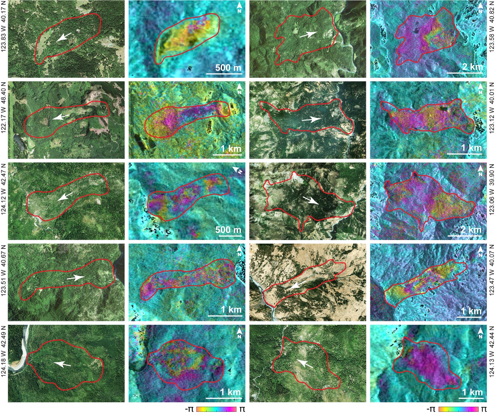
They found that 70% of the landslides they identified moved at a consistent pace, sliding farther down a slope from where they had been the year before. These landslides moved at rates of tens of centimeters to a few meters per year on average, Lu says.
But Lu notes that climate change could accelerate how quickly these landslides become catastrophic, as “climate change is producing abnormal climate situations.” For instance, it’s possible that record rainfall, similar to what was seen in Europe and China this year, could make some of the landslides on the West Coast worse.
Those landslides ranged in size from the equivalent of seven to 2,400 football fields.
Though InSAR has been highly effective at detecting landslides, Lu says there are likely still more unidentified slow-moving landslides on the U.S. West Coast because extremely dense forests may hinder InSAR’s capability to spot them. The InSAR satellite images are also less able to reveal landslide motions that are oriented perpendicular to the radar sensor’s “line of sight.”