Research
Volcano
related (selected) journal articles and books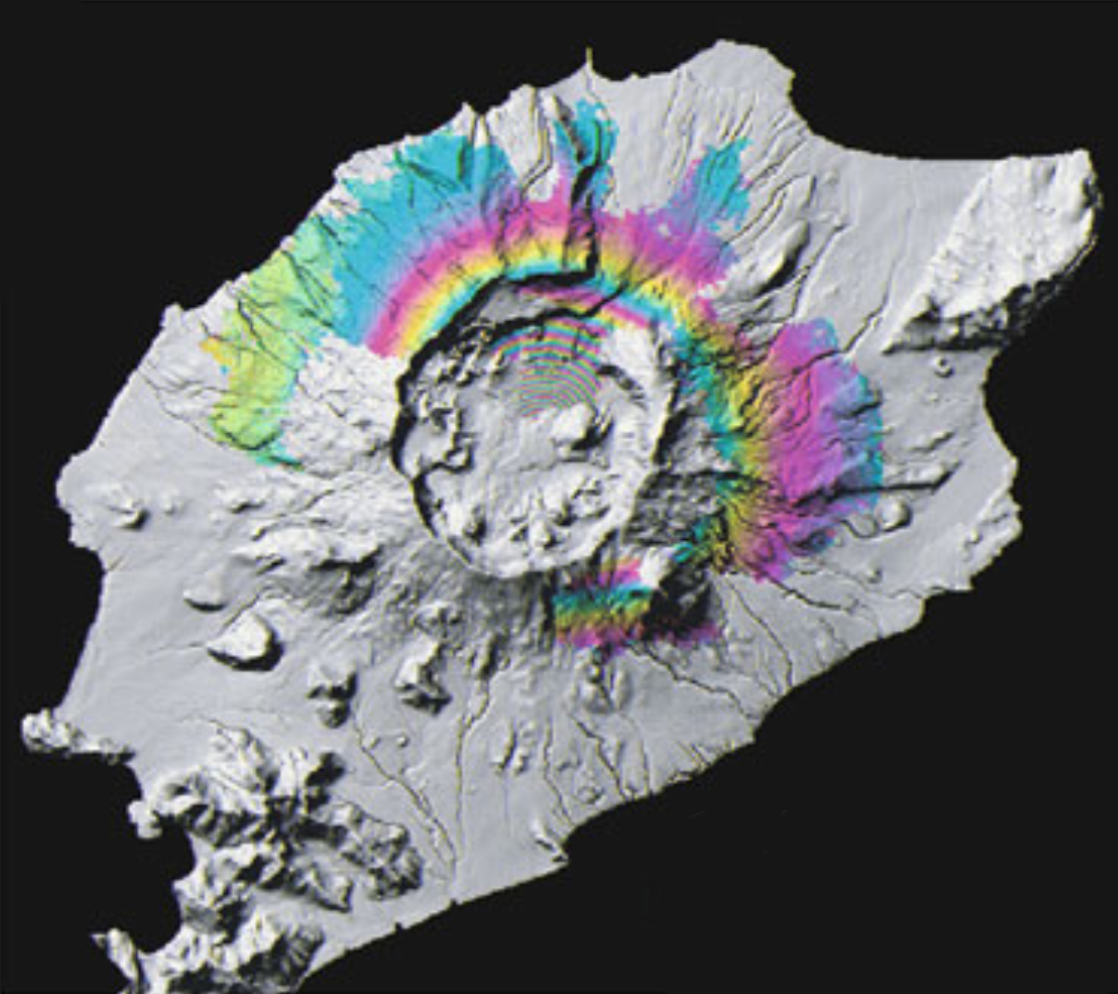
Lu, Z., Dzurisin, D., Wicks, C., and Power, J., 2015. Interferometric synthetic aperture radar (InSAR)—a long-term monitoring tool, p. 235-260, in: Dean, K.G., and Dehn, J., Monitoring Volcanoes in the North Pacific: Observations from Space, Springer-Praxis Books in Geophysical Sciences, ISBN: 978-3-540-24125-6.
Teng, W., Poland, M., Lu, Z., 2015. Dome growth at Mount Cleveland, Aleutian Arc, quantified by time-series TerraSAR-X imagery, Geophysical Research Letters, 42, doi:10.1002/2015GL066784.
Qu, F.F., Lu, Z., Poland, M., Freymueller, J., Zhang, Q., and Jung, H.S., 2015. Post-Eruptive Inflation of Okmok Volcano, Alaska, from InSAR, 2008–2014, Remote Sensing, 7, 16778–16794; doi:10.3390/rs71215839.
Lu, Z., and Zhang, L., 2014. Frontiers of Radar Remote Sensing: Photogrammetric Engineering & Remote Sensing, 80 (1), 5-13.
Lu, Z., 2007. InSAR Imaging of Volcanic Deformation Over Cloud-prone Areas—Aleutian Islands: Photogrammetric Engineering & Remote Sensing, 73 (3), 245-257.
Land Subsidence
related (selected) journal articles and books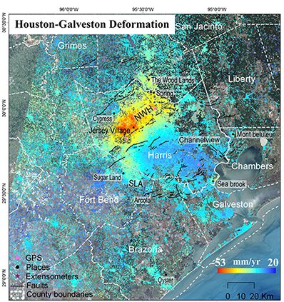
Qu, F.F., Lu, Z., Zhang, Q., Bawden, G.W., Kim, J.W., Zhao, C.Y., and Qu, W., 2015. Mapping ground deformation over Houston-Galveston, Texas using Multi-temporal InSAR, Remote Sensing of Environment, 169, 290-306.
Kim, J.-W., Lu, Z., Jia, Y., and Shum, C.K., 2015. Ground subsidence in Tucson, Arizona, monitored by time-series analysis using multi-sensor InSAR datasets from 1993 to 2011, ISPRS Journal of Photogrammetry & Remote Sensing, 107, 126-141.
Kim, J.W., Lu, Z., Qu, F.F., and Hu, X., 2015. Pre-2014 mudslides at Oso revealed by InSAR and multi-source DEM analysis, Geomatics, Natural Hazards and Risk, 6(3), 184-194, doi:10.1080/19475705.2015.1016556.
Qu, F.F., Zhang, Q., Lu, Z., Zhao, C.Y., Yang, C.S., and Zhang, J., 2014. Land Subsidence and Ground Fissures in Xi’an, China 2005–2012 Revealed by Multi-band InSAR Time-series Analysis: Remote Sensing of Environment, 150, 366–376, 10.1016/j.rse.2014.09.008.
Lu, Z., and Wicks, C., 2010. Study of the 6 August 2007 Crandall Canyon mine (Utah, USA) collapse from ALOS PALSAR InSAR: Geomatics, Natural Hazards and Risk, 1, 85-93.
Wetland
related (selected) journal articles and books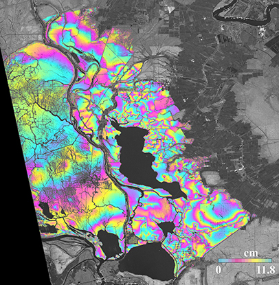
Lu, Z., Kim, J.-W., and Shum, C.K., Coastal Wetlands: Mapping by Interferometric Synthetic Aperture Radar (InSAR), in Encyclopedia of Natural Resources, Taylor & Francis, Volume 1, doi:10.1081/E-ENRL-120049157, ISBN 9781439852583, 2014.
Kim, J.W., Lu, Z., Jones, J.W., Shum, C.K., Lee, H., and Jia, Y., 2014. Monitoring Everglades freshwater marsh water level using L-band synthetic aperture radar backscatter: Remote Sensing of Environment, 150, 66-81.
Kim, J.W., Lu, Z., Lee, H.K., Shum, C.K., Swarzenski, C.M., and Doyle, T.W., 2009. Integrated analysis of PALSAR/Radarsat-1 InSAR and ENVISAT altimeter for mapping of absolute water level changes in Louisiana wetland: Remote Sensing of Environment, 113, 2356-2365.
Kwoun, O. and Lu, Z., 2009. Multi-temporal RADARSAT-1 and ERS backscattering signatures of coastal wetlands at southeastern Louisiana: Photogrammetric Engineering & Remote Sensing, 75 (5), 607-617.
Lu, Z. and O. Kwoun, 2008. Radarsat-1 and ERS interferometric analysis over southeastern coastal Louisiana: implication for mapping water-level changes beneath swamp forests: IEEE Transactions on Geoscience and Remote Sensing, 46 (4), 2167-2184.