Zhong Lu
Professor Shuler-Foscue Chair
| Phone |
214-768-0101 |
Education
PH.D., Geophysics, University of Alaska, Fairbanks, Alaska, 9/1992 - 8/1996 M.S., Geophysics, Peking University, Beijing, P. R. China, 9/1989 - 7/1992 B.S., Geophysics, Peking University, Beijing, P. R. China, 9/1985 - 7/1989Research Interests
- Technique developments on 1) synthetic aperture radar (SAR), interferometric SAR (InSAR), persistent scatterer InSAR (PSInSAR) processing, multi-aperture InSAR (MAI) processing and 3D deformation construction from InSAR and MAI/offset measurements, 2) high-resolution digital elevation model (DEM) generation with InSAR, 3) land cover characterization with SAR and Landsat imagery, and 4) InSAR deformation mapping with ERS-1, ERS-2, Radarsat-1, JERS-1, SIR-C, SRTM, Envisat, ALOS-1/-2, TerraSAR-X, TanDEM-X, COSMO-SkyMed, Sentinel-1A/B satellite SAR imagery.
- Research related to volcano deformation mapping, magma supply dynamics from InSAR imagery and numerical modeling, land subsidence and infrastructure stability monitoring and characterization, coastal deformation analysis with InSAR and hydrogeological models, landslide monitoring with InSAR and modeling, mapping and characterization of human-induced (mining, CO2 and wastewater injection, hydrocarbon extraction, sinkhole, ground fissure, etc.) deformation, co-/post-/inter-seismic deformation and seismic slip distribution and fault geometry from InSAR and modeling, imaging water-level changes in wetlands, soil moisture mapping with SAR/InSAR, flood mapping with SAR and optical imagery, vegetation characterization with SAR, glacier dynamics with InSAR, fire scar mapping with SAR and InSAR, arctic ice and water mapping with SAR/InSAR, etc.
Research Highlights
-
1. Subsidence over Gulf Coast
- GEOL 5356: Principle & Application of Remote Sensing
- GEOL 5399: Special Topics in Earth Sciences: Radar Principle & Application
- GEOL 6390: Radar Interferometry
- GEOL 3380: Introduction to Geophysics
- GEOL 6388: Geodynamics
- Basic Geophysics
Land subsidence is known to have occurred in plenty of areas over Gulf of Mexico, and caused extensive damages to manufactured constructions and increase in seawater intrusion leading to substantial loss of wetland habitat and more frequent flooding. The causes of the ground instability in the Gulf Coast are variant. Anthropogenic activities (groundwater withdrawal, oil/gas extraction, wastewater injection), and natural processes (sediment compaction and erosion, adjustment of the solid earth in response to changes in loading, and tectonics) have caused differential ground displacements and even activating faults. The Gulf Coast is vast with a size of ~500,000 km2, and bounded by Texas, Louisiana, Mississippi, Alabama, and Florida. InSAR has the capability to observe the extensive areas using multiple SAR satellites (ERS, ENVISAT, ALOS-1/2, Sentinel-1A/B, TerraSAR-X, COSMO-SkyMed). We have first monitored the ground subsidence over the Houston-Galveston metropolitan and identified the activated faults. Furthermore, we strive to map long-term small and large size deformation over the entire Gulf Coast from InSAR datasets, revealing their causes with supplementary data (GPS, extensometer, wellbore measurements), and understanding geophysical processes.
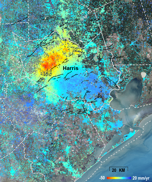 The average ground movement around the Houston area derived from InSAR images obtained from 1995-1998. During that time, the peak land surface drawdown was about 50 mm/year over Harris Country in northwestern Houston [Qu et al., 2015].
Houston-Galveston deformation map (interactive GIS map)
The average ground movement around the Houston area derived from InSAR images obtained from 1995-1998. During that time, the peak land surface drawdown was about 50 mm/year over Harris Country in northwestern Houston [Qu et al., 2015].
Houston-Galveston deformation map (interactive GIS map)

keywords: Gulf of Mexico, Gulf Coast, Land subsidence, Groundwater withdrawal, Wastewater injection, Hydrocarbon extraction, Sinkhole, Salt Dome, InSAR, Deformation mapping.
Grant:
NASA NNX16AL10G, “Mapping and characterizing land deformation over the Gulf Coast using multi-temporal InSAR processing.”
NASA 80NSSC19K1491, “Towards making NISAR a game changer for studying and monitoring volcano, landslide, and human-induced geohazards.”
References:
Qu, F.F., Lu, Z., Zhang, Q., Bawden, G.W., Kim, J.W., Zhao, C.Y., and Qu, W., 2015. Mapping ground deformation over Houston-Galveston, Texas using Multi-temporal InSAR, Remote Sensing of Environment, 169, 290-306. Download PDF
Kim, J.W., and Lu, Z., 2018. Association between localized geohazards in West Texas and human activities, recognized by Sentinel-1A/B satellite radar imagery, Scientific Reports, 8, 4727, https://doi.org/10.1038/s41598-018-23143-6. Download PDF
Zheng, W.Y., Kim, J.W., Ali, S.T., and Lu, Z., 2019. Wastewater leakage in West Texas revealed by satellite radar imagery and numerical modeling, Scientific Reports, 9, 14601, https://doi.org/10.1038/s41598-019-51138-4. Download PDF
Qu, F.F., Lu, Z., Kim, J.W., and Zheng, W.Y., 2019. Identify and monitor growth faulting using InSAR over northern Greater Houston region, Remote Sensing, 11, 1498, doi: 10.3390/rs11121498. Download PDF
2. Landslide studiesLandslide is the downslope movement of soil and/or rock under the influence of gravity, which is an important geomorphologic process, sculpturing the landscapes by transporting large volume of sediment from slopes to catchments through the fluvial system. Particularly, the northwest US undergoes the heavy rainfall in winter, resulting in hundreds of landslides and the expense of federal and state budget for fixing railways, highways, and dams. There has been obvious linkage between two different geohazard (precipitation, landslide), but the analysis of two hazards has been rather fragmented without fully integrating all the associated parameters. We have characterized the major hydrology-driven landslides in the northwest US (Washington, Oregon, northern California) in the large scale with high resolution and accuracy, using radar remote sensing techniques, InSAR, GPM, and SMAP soil moisture. Using multi-frequency SAR satellites (ALOS-1/2, Sentinel-1A/B), we have identified and monitored widespread landslides in northwestern US, which have not been archived to the landslide inventories of the federal and state authorities. Dense vegetation and heavy winter rainfall are major obstacles for landslides studies, but the application of the advanced InSAR techniques has helped unravel previously unidentified landslides from space. In cooperation with USGS, we have successfully completed the state-of-art landslide dynamic modeling for slow-moving and run-out events using D-Claw.
Pacific Northwest InSAR-based Landslide Map (interactive GIS map)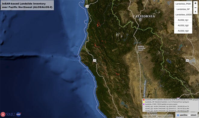
Keywords: Landslides, Pacific Northwest, Precipitation, InSAR, Landslide modeling, Landslide runout, D-Claw, Soil moisture, Precipitation, SMAP, GPM.
Grant:
NASA 80NSSC17K0022, “Development of an incorporated platform to characterize hydrology-driven landslide hazards in northwestern US”.
NASA 80NSSC19K1491, “Towards making NISAR a game changer for studying and monitoring volcano, landslide, and human-induced geohazards”.
NASA 80NSSC19K1317, “Using P-band AirMOSS to assess hazards of densely-vegetated deep-seated landslides in the Pacific Northwest”.
USGS Landslide Program, “Landslide studies in Glacier Bay National Park and Preserve and in Puerto Rico”.
References:
Lu, Z., Kim, J.W., 2021. A Framework for Studying Hydrology-Driven Landslide Hazards in Northwestern US Using Satellite InSAR, Precipitation and Soil Moisture Observations: Early Results and Future Directions, GeoHazards, 187, 49-61, https://doi.org/10.3390/geohazards2020002. Download PDF
Xu, Y., Lu, Z., Schulz, W.H., and Kim, J.W., 2020. Twelve-year dynamics and rainfall thresholds for alternating creep and rapid movement of the Hooskanaden landslide from integrating InSAR, pixel offset tracking, and borehole and hydrological measurements, Journal of Geophysical Research: Earth Surface, 125, e2020JF005640, https://doi.org/10.1029/2020JF005640. Download PDF
Hu, X., Lu, Z., Pierson, T., Kramer, R., George, D., 2018. Combining InSAR and GPS to determine transient movement and thickness of a seasonally active low-gradient translational landslide, Geophys. Res. Lett., 45, 1453–1462, doi: 10.1002/2017GL076623. Download PDF
3. InSAR imaging of Aleutian volcanoesWith its global coverage and all-weather imaging capability, InSAR has become an increasingly important technique for studying magma dynamics at volcanoes in remote regions, such as the Aleutian Islands. The spatial distribution of surface deformation derived from InSAR data enables the construction of detailed mechanical models to enhance the study of magmatic processes. To study Aleutian volcanism, Lu and Dzurisin [2014] processed nearly 12,000 SAR images acquired by ERS-1, JERS-1, ERS-2, Radarsat-1, Envisat, ALOS, and TerraSAR-X from the early 1990s to 2010. They combined these SAR images to produce about 25,000 interferograms, which we analyzed for evidence of surface deformation at most of the arc’s Holocene volcanoes. Where surface displacements were sufficiently strong, we used analytical models to estimate the location, shape, and volume change of deformation sources.
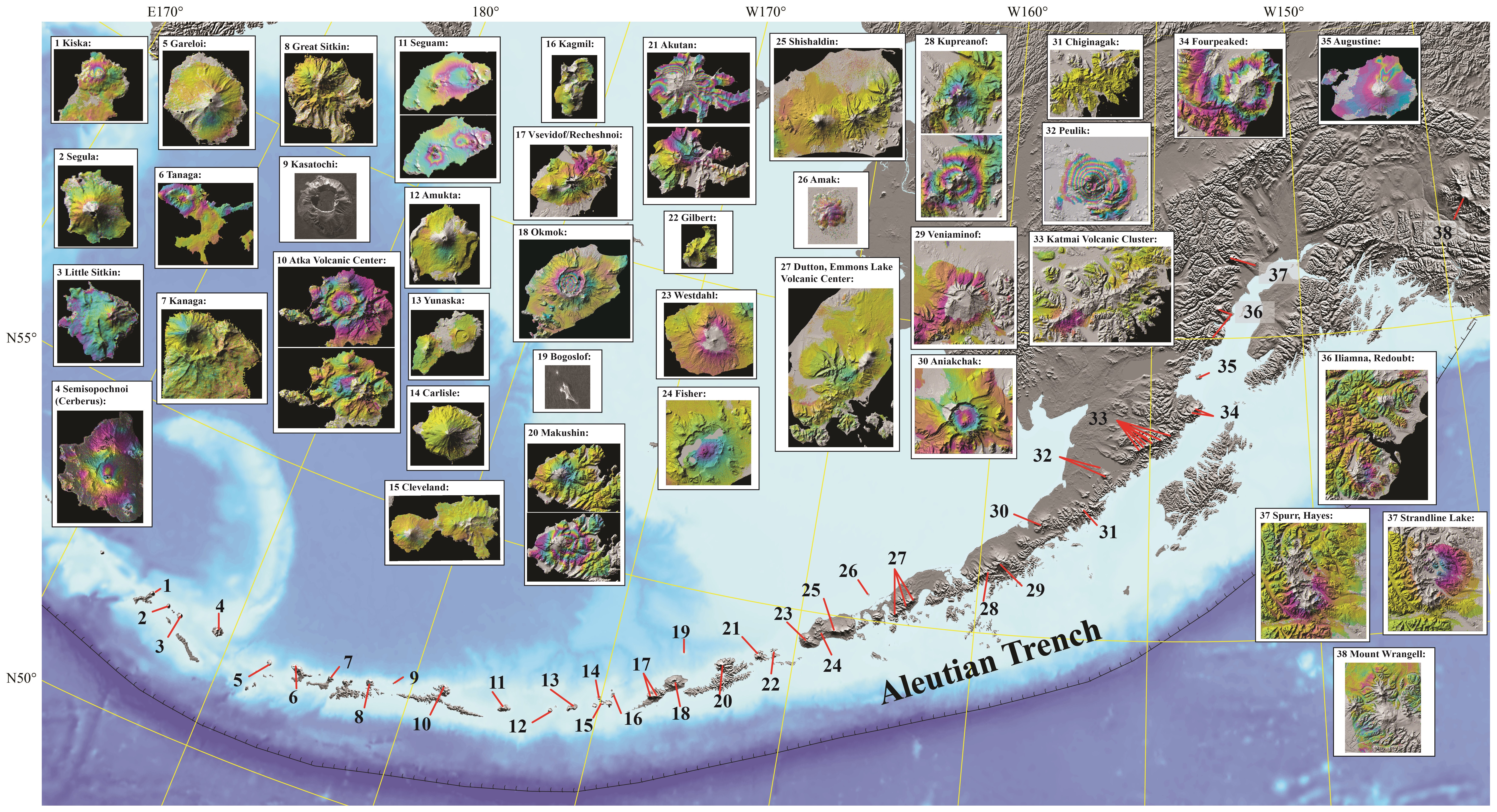 Snapshots of deformation of historically active volcanoes in the Aleutian arc from InSAR [Lu and Dzurisin, 2014].
The deformation processes at Aleutian volcanoes observed with InSAR include: (1) time-variant volcanic inflation and magmatic intrusion, (2) deformation preceding and accompanying seismic swarms, (3) persistent volcano-wide subsidence at calderas that last erupted tens of years ago, (4) episodic magma intrusion and associated tectonic stress release, (5) subsidence caused by a decrease in pore fluid pressure in active hydrothermal systems, (6) subsidence of surface lava and pyroclastic flows, and (7) a lack of deformation at some volcanoes with recent eruptions, where deformation might be expected. Among the inferred mechanisms are magma accumulation in and withdrawal from crustal magma reservoirs, pressurization/depressurization of hydrothermal systems, and thermo-elastic contraction of young lava flows [Lu and Dzurisin, 2014]. Lu and Dzurisin’s work demonstrates that deformation patterns and associated magma supply mechanisms at Aleutian volcanoes are diverse and vary in both space and time. By combining InSAR results with information from the geologic record, accounts of historical eruptions, and data from seismology, petrology, gas geochemistry, and other sources, they have developed conceptual models for the magma plumbing systems and behaviors of many volcanoes in the Aleutian arc. Even though these models are simplistic, but Lu and Dzurisin hope that they will serve as foundations that will be refined as additional information becomes available [Lu and Dzurisin, 2014].
keywords: Aleutian Islands, InSAR, Deformation modeling, Magma dynamics, Inflation, Magmatic intrusion, Seismic swarm, Subsidence, Hydrothermal system, Flow contraction.Grant:
NASA NNX14AD95G, “Real-time monitoring of active volcanoes with an optimized L-band DESDynI-R sensor”.
NASA NNX16AK56G, Toward Making NISAR a Game Changer for Studying Volcanic Processes and Monitoring Volcanic Hazards”.
NASA 80NSSC19K1491, “Towards making NISAR a game changer for studying and monitoring volcano, landslide, and human-induced geohazards.
References;
Lu, Z., and Dzurisin, D., 2014. “InSAR Imaging of Aleutian Volcanoes: Monitoring a Volcanic Arc from Space”: Springer Praxis Books, Geophysical Sciences, ISBN 978-3-642-00347-9, Springer, 390 pp. (http://link.springer.com/book/10.1007%2F978-3-642-00348-6).
EXPERIENCE
11/2013 – present, Shuler-Foscue Professor of Earth Sciences, Southern Methodist University.
12/2006 – 10/2013, Physical Scientist, U.S. Geological Survey, Cascades Volcano Observatory
3/1997 – 11/2006, Principal Scientist &Technical Fellow, Science Applications International Corporation, contractor to the U.S. Geological Survey/EROS,
9/1996 - 2/1997, Postdoctoral Research Associate, Geophysical Institute of University of Alaska
9/1992 - 8/1996, Research Assistant, Geophysical Institute, University of Alaska
COURSES TAUGHT
GRADUATE STUDENT OPPORTUNITIES
I am looking for enthusiastic, persevering students pursuing Ph.D. degrees in geophysics on areas of volcano, landslide, coastal subsidence, and human-induced geohazard using InSAR and deformation modeling.
Publications / Media Reports