SMU seismology team committed to Irving-area earthquakes study
An SMU seismology team continues studying the cause of recent earthquakes in nearby Irving.
Jan. 29, 2015 Statement from SMU seismologist Brian Stump:
Our research group at SMU is committed to supporting the local communities in both recording and assessing the earthquakes that occur in our area, including the ongoing sequence. For this current earthquake sequence, we have been fortunate to receive assistance in the form of loaned equipment, technical assistance and other important support from a wide range of community leaders, governments, and interested citizens. This has made the initial local observation effort possible and we gratefully acknowledge these contributions.
|
Report an Earthquake to the USGS "Did You Feel It?" site. Jan. 6 media briefing on earthquakes. B-Roll of Irving installation Jan. 5 A sample of news coverage of the Irving quakes. 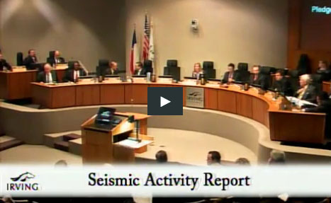 The presentation to the Irving City Council |
As part of our commitment, we are pursuing funding and equipment loans from federal sources to support long term, broader goals for the region that I referenced in my comments to the Irving City Council.
At a meeting earlier this week with Dallas and Irving emergency planners we were asked to spell out the projected costs of studies similar to those we are currently just beginning in the Irving area. My answer was intended to help plan future activity and longer term studies. Such estimate includes the following three components:
The first step in assessing both the hazard and cause of an earthquake sequence is to accurately locate and characterize the sequence. Most of Texas, and certainly North Texas, is poorly instrumented for earthquake monitoring. As a result, we need observations from temporary deployments of local seismographic stations for this purpose. Instruments for these deployments typically rent for $1000/month per instrument or sell for $10,000 to $25,000. A typical local network will include ten instruments and may require observation for several years. Fortunately in all the previous studies, including the Irving sequence, we have been able to borrow instruments. We especially appreciate the instruments made available by the USGS, IRIS (Incorporated Research Institutions in Seismology) and SMU. However, there are competitive demands on the instrument loans and our loans are subject to instrument calls should there be a high priority scientific need elsewhere. For example, when the current swarm of Earthquakes began occurring in the Irving area, most of the equipment previously loaned to SMU was (and is) still in the field in Azle.
The second cost component is associated with deployment and maintenance of instruments, acquisition of the data (telemetry), archival of data and actual review of the data. For the current studies, as a result of local cooperation these expenses have been shared with support provided by the university and data telemetry and logistics support from the city of Irving. We estimate that network operations of this size may cost $100,000 annually.
Finally, there is the effort needed to analyze and interpret the resulting data. As we have noted there is need for sharing subsurface geology, fault locations, and any details of relevant human or industrial activity. Each of these data sources have costs associated with them. The subsequent integration of the data sets and model testing provide the basis for understanding the earthquake causes require a range of expertise that up to this point we have provided through SMU for the earthquake studies. Typically our experience with funded studies of a similar nature suggests that the costs are similar to the operation of the instrumentation, about $100,000 per year.
We intend to move forward with all of our efforts to study these earthquakes even if we do not receive additional financial support. Naturally the speed of the study is impacted by our other university activities, and it’s not unlikely that we will need to study another swarm of earthquakes at a later date – perhaps while instruments are still in the field in the Irving area.
As Dr. Heather DeShon and I stated before the Irving City Council Jan. 15, “It is my opinion that these recent events - in the context of the increase in seismicity we’ve seen in our area since 2008 - are strong motivation for a comprehensive assessment of the increased seismicity rate across North Texas.” Of course this is our personal opinion only, but an effective comprehensive assessment will take comprehensive financial support as well as data sharing across government, academia and industry.
BrianStump is SMU Claude C. Albritton Chair in Geological Sciences, whose previous research includes studies of earthquakes that began in the DFW airport area in 2008 and in the Cleburne area in 2009.
Remarks prepared by SMU seismologists for Jan. 15 Irving City Council meeting
Presented by Brian Stump, the Albritton Chair of Geological Sciences at SMU
I would like to thank you, the Irving City Council, for the opportunity to appear tonight and discuss the recent seismic activity in the area. These earthquakes highlight the dynamic interplay of stresses and old faults within the earth’s crust, even here in the flatlands of North Texas, and the need to understand how and when such stresses can give rise to earthquakes. To date, all of the North Texas earthquakes have been small, less than magnitude 4. The fact that they have been widely felt and have continued over months has naturally raised concerns.
The seismologists at SMU have been recording earthquakes in North Texas since 2008, but it is only with the close cooperation of local community governments, officials, organizations, and citizens willing to help deploy and host seismographs that such critical observations are possible. In this most recent case for example, Jason Carriere, the Emergency Management Coordinator for the Irving Police Department and his colleagues and peers have made possible the very rapid deployment of seismographs following the M3.5 and 3.6 earthquakes only 9 days ago.
I have prepared short remarks and then we are available for questions that you might have. My intention with these remarks is to highlight four points:
- First, I’ll summarize the ongoing seismic activity in Irving-Dallas in the context of the rest of the seismicity that has occurred in the Fort Worth Basin since 2008;
- Second, I’ll provide an overview of the current study of the Irving earthquake swarm and anticipated outcomes;
- Third, I’ll list possible subsequent steps following the deployment of instruments designed to explore the cause of the activity; and
- Finally, I’ll have some brief remarks concerning assessment of earthquake hazards and preparation going forward.
The overview of past and ongoing research related to possible linkages between human activities and earthquakes will not be explicitly covered tonight although you have been supplied the materials we presented to the Texas House Subcommittee on Seismicity on 12 May 2014 and it is also available at: www.smu.edu/News/NewsIssues/EarthquakeStudy.
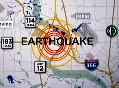
The Irving earthquake sequence appears to have begun on 17 April 2014 with a magnitude 2.4 event and has been followed by thirty-seven additional events as identified by the United States Geological Survey (or USGS), including the magnitude 3.5 and 3.6 earthquakes last Tuesday. A number of these have been widely felt across the area with a total of four above magnitude 3. Because the two largest events are of almost equal magnitude and occurred close in time to one another, we and others have called this an earthquake swarm as opposed to a single main earthquake followed by aftershocks.
It is important to put this swarm into the context of the activity that has occurred across the DFW Metroplex since Halloween night 2008. Prior to 2008 there were no historic seismic events in the area and only one possible felt event reported in 1950. Of course the ability to detect and locate seismic events in the region has increased as a function of time, but with the substantial population in the region for well over 100 years, any felt reports associated with small events would have been made and those events would have been identified. As an aside, I would like to encourage everyone to file reports on the earthquakes they feel using the USGS “Did You Feel It” website (earthquake.usgs.gov/earthquakes/eventpage/dyfi/). We have great technology, but reports from people who have felt earthquakes are quite useful in interpreting the location of an earthquake, its size and how seismic waves decrease in amplitude as they move away from the earthquake source. Since October 31, 2008, the USGS has located over 120 earthquakes in our area. The Irving earthquakes represent the fourth sequence to be studied in our local area over the last six years. The first was an earthquake sequence centered near DFW airport in 2008 and 2009 with the largest magnitude of 3.3. A second sequence from 2009 into 2010 was near Cleburne, Texas with the largest magnitude of 2.8. A third set of events occurred near Azle, Texas beginning in the Fall of 2013 and continuing through 2014 with the largest magnitude of 3.6. In all of these cases earthquakes got smaller and further apart in time following the largest events. Additional focus areas of seismicity based on USGS locations exist NE of Cleburne, near Mineral Wells and in the Venus/Midlothian area but have not been well studied. Within the context of the increased seismicity in the area, the most recent swarm has similar characteristics to the others.
Turning to the recent Irving swarm, it is important to recognize that the USGS has primary responsibility in the US for locating earthquakes as well as providing earthquake hazard assessment. They complete this task with a high quality network of seismic stations deployed across the United States. In the case of the largest Irving earthquake, the existing USGS seismic stations used to first locate the event were as close as 40 miles and as far as 922 miles. As you can imagine, using seimic waves from such distant stations typically results in intrinsic errors in location estimates that can be as large as 3-6 miles. These errors are large enough that it can be difficult to assign an earthquake or swarm to a particular fault, which is critical to understanding the process. As a result, the deployment of additional seismic stations closer to initial earthquake location estimates provides the basis for refining these locations in order to attribute them to a fault. In areas such as California where earthquake activity is high, permanent seismic stations are already installed with spacing adequate to provide these types of refined earthquake locations. We in North Texas do not have such a network.
Before Tuesday, January 6, there were only three seismic stations within about 10 miles of the events, one of which was deployed on Monday afternoon, January 5. In order to improve our mapping of the fault causing these earthquakes, over the last week we have worked with the City of Irving and others to deploy additional seismometers designed to provide high precision locations. Today we have a total of 22 instruments fielded, although 14 of them are designed to record for only 10 days and will be recovered by the end of the week. Data from a number of these instruments is being shared with the USGS in order to enhance their real-time analysis of any subsequent earthquakes. We anticipate that within the next month as additional small events occur that these data will provide the basis for a refinement of our understanding of the responsible fault. This same approach proved to be successful for the earthquake sequences that occurred near DFW airport, Cleburne and Azle. The timing of this work is dependent on how much longer subsequent earthquakes occur in the coming weeks. Once the fault location is refined, the data provdes a basis for improving the location estimates of the earthquakes that occurred before the local stations were deployed. Thanks to the support of City of Irving, this deployment subsequent to the largest events last Tuesday has been the most rapid of any of the sequences in the area and will provide one of the best data sets for assessing the swarm.
Finally, I want to touch briefly on the seismic activity and its possible hazard to our communities. It is important for you to understand that this area is beyond our specific expertise and an important area for continued cooperation with the USGS. All of the events since 2008 have been small and, although startling to all of us when we feel them - they have not been large enough to cause significant damage. The fact that the events appear to be shallow, 2-5 miles deep, means they are close to the surface where we live and thus well felt. The previous sequences have decayed away following the largest event with magnitudes similar to those experienced last Tuesday. I do not know whether this specific swarm will die out or whether it will continue. Experience shows that the majority of earthquake swarms do not result in damaging earthquakes. But at this time we cannot rule out the possibiltiy of larger earthquakes, some possibly damaging. I believe these statements are consistent with guidance provided by the USGS. Recent earthquakes in West Texas, East Texas and South Texas have been large enough that they might cause some damage if they occurred in our area, and thus motivates the assessment of current seismicity in our local area and meetings like this one tonight. The USGS is an excellent resource for both hazard assessment and preparedness and therefore I encourage the local governments to work with these experts.
I close with thanks again for the leadership of the City of Irving, the support of the City of Dallas, the cooperation of the USGS, instrumentation from IRIS, and help provided by a number of individuals in the area over the last ten days. These events have led to cooperation and collaboration with a number of groups, governments and organizations. It is my opinion that these recent events - in the context of the increase in seismicity we’ve seen in our area since 2008 - are strong motivation for a comprehensive assessment of the increased seismicity rate across North Texas. Communities need to be able to make informed decisions about preparation as well as improve hazard assessment. Such a comprehensive study will need to involve contributions from a diverse collection of individuals within government, industry and academia with expertise across a broad spectrum.
January 7 statement from SMU Seismology Team
DALLAS (SMU) – SMU’s seismology team will deploy 22 more seismographs in the Irving area over the next few days to better understand the series of earthquakes that United States Geological Survey (USGS) data indicates are occurring on or near the site of the old Texas Stadium.
Fifteen monitors are being deployed today, Jan. 7. Two more being provided by the USGS are expected to arrive and be deployed Thursday, and another five provided by Incorporated Research Institutions for Seismology (IRIS) are scheduled for deployment Friday.
The SMU scientists stress that learning more about this recent series of earthquakes will be an incremental process.
“In the near term, our first step is to put out seismographs to confirm and refine the location of the quakes and define the faults in the area,” said Heather DeShon, associate professor of physics at SMU. “Only after we get that data will we be in a position to investigate the potential cause of the earthquakes.”
The current earthquakes are the fourth sequence of felt earthquakes recorded in the Fort Worth Basin since 2008. The previous earthquakes sequences occurred near DFW Airport, Cleburne, and the Reno-Azle area. SMU studies of the DFW and Cleburne quakes cited wastewater injection wells as a plausible cause of the seismicity in those areas. Information on those previous SMU studies is available at http://www.smu.edu/News/NewsIssues/EarthquakeStudy. The report on the earthquakes in the Azle-Reno area has not yet been released.
“It’s premature to speculate on the cause of this current series of seismic events,” said Brian Stump, SMU’s Albritton Chair of Geological Sciences. “We’re just getting started. We want to support the local community in understanding these earthquakes, and the team appreciates the cooperation of the City of Irving, the United States Geological Survey and IRIS in helping us get the best information possible.”
January 6 statement from SMU Seismologist Brian Stump
SMU’s seismology team is committed to helping North Texans understand more about the increasing number of earthquakes felt in our region over the last few years, most recently near the City of Irving.
A 2.4-magnitude earthquake recorded at 8:29 p.m. Jan. 1, 2015, and estimated to be near the old Texas Stadium site was the 17th earthquake felt in the area since early September.
An SMU team installed one portable seismometer in a building on the northeast side of the City of Irving Monday, Jan. 5, aiming to supplement data being collected from more distant sites by the United States Geological Survey to identify the location of the quakes. The location of the Irving seismometer is not being made public to preserve the integrity of the data it collects.
This latest installation provides a third source of data SMU can tap in helping to determine the location of the Irving-area earthquakes. The seismology team also can retrieve data from a University-controlled portable seismometer previously installed at a site south of DFW airport, as well as the seismometer permanently installed in the basement of Heroy Hall on the SMU campus.
SMU’s interest in these Irving-area earthquakes is at this point focused on helping to identify their exact location.
The University’s seismology team is not currently engaged in a larger study of the cause of the Irving quakes, but I will brief the Irving City Council Jan. 15 on what data might be expected from the Irving installation, as well as on the results of past research into earthquakes in the Fort Worth Basin. Information on those previous SMU studies is available at http://www.smu.edu/News/NewsIssues/EarthquakeStudy.
There has been a significant increase in earthquakes in the Fort Worth basin since October 2008. It’s important to all of us to learn as much as we can about them.
Related Links:
- Irving, Texas: Presentation to the City Council
- The Dallas Morning News: SMU seismologists discuss earthquakes with residents at Irving City Hall
- SMU: North Texas Earthquake Study: Understanding recent North Texas seismicity
- KERA Public Radio: Earthquakes in North Texas
- PhysOrg: Scientists look for what's causing Texas earthquakes
- The Dallas Morning News: What’s at fault? Scientists seek cause of Irving earthquakes
- The Dallas Morning News: What lies beneath Irving?
- NBC 5 News: 4 More Earthquakes Strike Irving Wednesday
- Fox 4 News: 12 earthquakes rattle North Texas in 48 hours
- WFAA News: 22 new seismographs to be deployed in Irving
- KERA Public Radio: After 12 Quakes In 2 Days, Scientists Deploy More Seismographs In Irving
- SMU Research Blog: SMU scientists stress that learning more about this recent series of earthquakes will be an incremental process
- The Fort Worth Star-Telegram: Irving police ask public to ease up on quake calls
- Reuters: Texas seismologists investigate quakes near old Cowboys stadium
- The Associated Press: Minor Earthquakes Rattle Northern Texas
- National Geographic: Are Oil and Gas Industries Behind the Rare Texas Earthquakes?

About the Seismology Team
 |
Brian Stump, SMU Claude C. Albritton Chair in Geological Sciences, whose previous research includes studies of earthquakes that began in the DFW airport area in 2008 and in the Cleburne area in 2009. | |
 |
Heather DeShon, SMU associate professor of geophysics, led the Reno-Azle research team, and a report is pending. | |
 |
Chris Hayward, senior scientist and director of the Geophysics Research Program. | |
 |
Matt Hornbach, Associate Professor of Geophysics | |
 |
Beatrice Magnani, Associate Professor of Geophysics | |
 |
Remi Oldham, SMU geophysics graduate student and member of the monitor installation team. | |
 |
Mason MacPhail, SMU geophysics graduate student and member of the monitor installation team. | |
 |
Chris Cain, SMU seismo-acoustic technician. | |
 |
Kevin Kwong, SMU geophysics graduate student. |