![University Boulevard - Hillcrest Road [unlabeled]](/-/media/Site/Libraries/digital-collections/apnd/apnd_slideshow_a_unlabeled.jpg)
University Boulevard - Hillcrest Road [unlabeled]
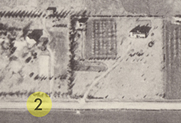
![University Boulevard - Lemmon Avenue [unlabeled]](/-/media/Site/Libraries/digital-collections/apnd/apnd_slideshow_aaa_unlabeled.jpg)
Coca Cola Syrup Plant from University Boulevard - Lemmon Avenue [unlabeled]
Mockingbird Lane - Preston Road [Labeled]
Walnut Hill Lane - Hillcrest Road [Labeled]
![NW HWY - Inwood Road [unlabeled]](/-/media/Site/Libraries/digital-collections/apnd/apnd_slideshow_f_labeled.jpg)
NW HWY - Inwood Road
[Unlabeled]
About the Collection
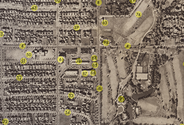
![[Aerial Photos of the Northern Part of Dallas (composite)]](/-/media/Site/Libraries/digital-collections/apnd/g4034s_d2_a4_1940_l7_stitched.jpg?h=694&w=700&hash=E76AF7A6C1F26A84EB91DABE6988D886)
These aerial photos of the northern part of Dallas, Texas, east of Love field, west of White Rock Lake, and north of Beverly Drive were taken by Lloyd M. Long ca. 1940. Areas shown include Highland park and University Park.
The photographs are part of the Foscue Map Collection. The library worked with regional historian George Cearley to identify important features in the photographs such as major roads, railways, and landmarks. A transparent overlay with locational markers was created for each photograph to label these features. In the digital collection, there are two versions of each image, labeled and unlabeled. Labeled images replicate the physical overlays created for the originals and correspond to a legend that appears in the Labeled Features metadata field below the image.
About Lloyd M. Long
Described in the Dallas Morning News as "a pioneer in the field of aerial photography," Lloyd Long was a prominent citizen and an important part of Dallas' aviation history. Born in 1896 in Spokane, Washington, Long finished a graduate degree in business at MIT in 1917 and thereafter became a senior instructor in aerial photography at the U.S. Naval School at MIT. After World War I ended, Long moved to Dallas in 1920 to join Fairchild Aerial Survey, Inc. While working there, he helped to develop the Fairchild camera, which featured a shutter placed between the lenses to allow for better aerial pictures. This camera system became standard on aerial cameras for the next 50 years.
Long also founded his own company, Long Aerial Photographic Service on North Akard, specializing in aerial and industrial photography. This collection's images were taken as part of his work in this business. Several of his aerial photographs were printed at various times in the Dallas Morning News. He was a vocal advocate for the Ulrickson Plan in 1927 that went on to overhaul the Trinity River levees as well as the water and sewer systems, and his interest in Dallas' development can be seen throughout his work. He was the chairman of the Dallas Flying Club and was a director for the Aviation Cadets of America in the years leading up to the second World War. He performed secret work for the FBI during World War II. Long lived and worked in Dallas until he died in 1956.
View more aerial photographs of Dallas in these collections from the Foscue Map Collection:
Copyright usage terms vary throughout the collection. Each item contains information about usage terms. If SMU does not have the right to publish the item on the Internet, only the item's metadata will be available and the digitized object will be available on a restricted access basis. Such items may only be viewed on campus. When items are available for use, please cite Foscue Map Collection, SMU Libraries. For more information, contact degolyer@smu.edu