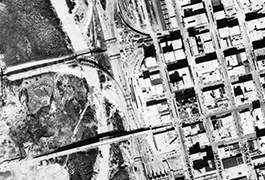
Deep Elm "Deep Ellum" Downtown Dallas (Unlabeled)
Downtown Dallas (Unlabeled)
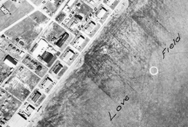
Dallas Love Field, Bachman Lake (Unlabeled)
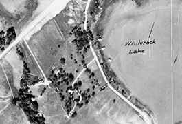
White Rock Lake Northwest (Unlabeled)
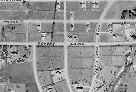
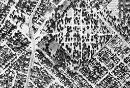
University Park Area (Unlabeled)
About the Collection
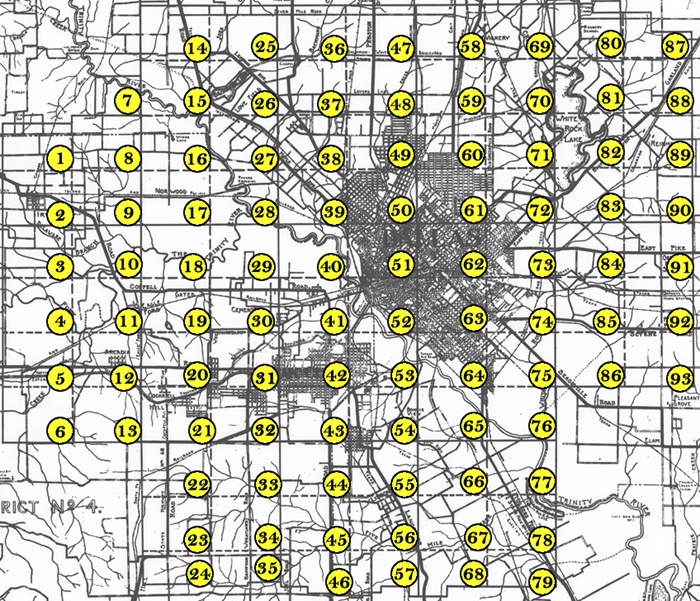
The 93 images in the Dallas Historic Aerial Photographs, 1930 Fairchild Survey digital collection represent a complete set of air images commissioned by the City of Dallas and photographed by Sherman Mills Fairchild in October of 1930 flying out of Love Field. SMU's Foscue Map Collection retains all but eight of the 93 images as well as a photo image of the master grid map (on right). All images are 19” x 23.5” prints.
Aerial Survey Grid
To view an individual high-resolution image, click on the area of the map you wish to examine. When you do so, you will be taken to the web page for that image that contains a high-quality aerial photograph with yellow markers and a corresponding legend of places.
Place names are displayed in the key below the image. To zoom in and move
around, use the tool bar across the top of the image. The small image to the
left will tell you what part of the photograph you are viewing by
displaying a shaded red area around the portion of the image you are viewing.
Each image also contains a link to the unlabeled version of the same photograph.
About the Collection
About the Originals
The City of Dallas Municipal Archives retains copy negatives for most of these prints. At the time the digital collection was created, Dallas Archivist John Slate believed these copy negatives were produced in the late 1960s or early 1970s. They are not the original negatives from the 1930 aerial survey. While several libraries house some or all of the 1930 prints, no known set of the original negatives exists.
Staff at the Edwin J. Foscue Map Library worked with regional historian George Cearley to create identifications for more than 3,500 specific landmarks within these aerial photographs. These identifications are available online as an overlay so the images and identifications may be explored not only by zooming in and out but also by offering unique tags that name and describe what the viewer is seeing. This replicates the physical overlays created in the Edwin J. Foscue Map Library.
 About Fairchild Aerial Surveys
Aerial photography began in the nineteenth century from balloons. It expanded in the First World War (1914-18) when the value of military reconnaissance from airplanes became obvious. After the war, photography from the air came quickly to be used for a variety of purposes. For example geological surveying, mapping, and, in the case of photographing cities from the air, tax assessment. As cities expanded, it proved far quicker and cheaper to make the maps needed for tax purposes from pictures taken from airplanes than by traditional surveying techniques on the ground.
Sherman Mills Fairchild (the son, incidentally, of a man whose company eventually developed into IBM) was by 1919 a leader in the design of cameras for aerial photography. In 1924 he founded Fairchild Aerial Surveys, Inc. The company’s first contract was to produce a photo-map of Newark, New Jersey. Fairchild soon also began producing airplanes. His FC-2, first made in 1927, was a five-seat, high-wing monoplane. The type could be, and often was, used for aerial photography. The Fairchild airplane company went out of business in 2002, although one of its products, the A10-A Thunderbird II (also known as the “Warthog”), a powerful ground-support plane, is still in service with the United States Air Force. (Contributed by Peter Bakewell, Aviation Historian, SMU).
Project Contributors
George Cearley (historic identifications), Sarah Roberts (metadata entry), John Slate (City of Dallas Archivist), Dawn Youngblood (curator), nCDS (digitization, metadata).
Scholarly Reviewers: Peter Bakewell, John Chavez, Bonnie Jacobs, Ben Johnson, Darwin Payne.
View more aerial photographs of Dallas in these collections from the Foscue Map Collection:
Copyright usage terms vary throughout the collection. Each item contains information about usage terms. If SMU does not have the right to publish the item on the Internet, only the item's metadata will be available and the digitized object will be available on a restricted access basis. Such items may only be viewed on campus. When items are available for use, please cite Foscue Map Collection, SMU Libraries. A high-quality version of these files may be obtained for a fee by contacting degolyer@smu.edu.